
In this guide
A two- or three-day Mount Desert Island plan with the actual vehicle requirement separated.
All topics and planning links
Match the outing to your access needs
Use the named park’s official accessibility information and ask about the exact surface, slope, distance and transport you need.NPS park websites provide information about accessible features, programs and services. Use the named park’s information to check surface, slope, distance and transport for the outing you actually choose.Checked 2026-10-07 · Source
A pond day and a coastal day
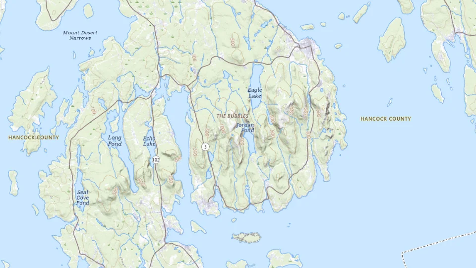
Jordan Pond supplies an inland water-and-mountain setting. Sand Beach, Thunder Hole and Otter Cliffs form another coastal area to consider. Choose the actual walking route and access rather than assuming each photograph represents a short roadside stop.
For a first visit, keep one landscape as the main outing and leave time in the nearby base afterwards. Bar Harbor can support town evenings, while another island address changes the approach. A peninsula outside the main island plan needs its own travel day.

Start with this decision
Choose Bar Harbor for town services and eastern Mount Desert Island sights. Stay near Southwest Harbor for western-island plans. Treat Schoodic as its own outing or base, not a quick stop across the bay.
- Suggested stay
- Choose the nights around your arrival, departure and selected outings.3–4 daysPlanning estimate · reviewed 2026-10-06 · Source
- Getting around
- Check the actual route and current transport for the dates and base you choose.Useful for the wider area; seasonal buses can help with selected park routes.Planning estimate · reviewed 2026-10-06 · Source
- When to go
- Check the intended season, official access and local conditions before booking.Late spring through fall; seasonal transport and roads need checking.Planning estimate · reviewed 2026-10-06 · Source
Give a shoreline walk, a lake or carriage-road outing and a summit plan separate space. Fog can make a summit less rewarding while improving the atmosphere of a coastal walk.
Choose your base
- Bar Harbor
- Southwest Harbor
Map sources and credits
USGS The National Map: National Boundaries Dataset, 3DEP Elevation Program, Geographic Names Information System, National Hydrography Dataset, National Land Cover Database, National Structures Dataset, and National Transportation Dataset; USGS Global Ecosystems; U.S. Census Bureau TIGER/Line data; USFS Road data; Natural Earth Data; U.S. Department of State HIU; NOAA National Centers for Environmental Information. Data refreshed September 4, 2026-v1.2
Original map service| Area | Choose it for | Tradeoff |
|---|---|---|
| Bar Harbor | A first visit with town evenings. | Busy dates bring parking pressure. |
| Southwest Harbor | West-side sights and a quieter base. | Eastern sights require a separate drive. |
A sensible first visit
- Explore the eastern coast and leave room for weather.
- Use a day for a lake or carriage-road route and a reserved summit drive if conditions fit.
- Add the west side or Schoodic with enough travel time.
Choose the activities that fit
Ocean Path and coastal stops
A first coastal introduction. Waves and slippery rocks require distance from the edge.
Half day · Self-guided walk
Check ocean path and coastal stops detailsCarriage roads or a lake outing
A change from the rocky coast. Surface, gradient and bicycle rules vary.
Half day · Walk or permitted bicycle ride
Check carriage roads or a lake outing detailsBefore you book
Check the official visitor information for current access, booking requirements and restrictions in Acadia National Park before choosing dates or paying. The previous operational note is awaiting a fresh review.A park entrance pass and a Cadillac Summit Road vehicle reservation are different things. Verify current seasonal requirements, shuttle schedules and trail restrictions.
The summit road is one visit with one booking question
Cadillac Mountain adds a summit setting to the coastal park. During the applicable reservation period, driving Cadillac Summit Road requires the separate vehicle product. Read the current NPS dates and conditions before buying it; a park entrance pass is a different requirement.
A sunrise plan creates an early start and weather uncertainty. A daylight summit visit or another suitable park interval can be the better choice for a family. A summit ticket does not guarantee visibility or make every walking route suitable.

Keep the quiet side and the main island in perspective
Bass Harbor and another island interval give a different setting from the busiest east-side visits. Choose them because that part of the island matters to the trip, then allow the approach. Do not stack every coast photograph into one short afternoon.
Use the current Island Explorer service and route information when planning a less car-dependent visit; seasonal transport needs an actual timetable. For a longer holiday, combine Acadia with the New England route and preserve enough nights in the park area.

A short day in The Ocean Path area
Car or current seasonal transit to an appropriate starting point.
Allow roughly half a day, plus arrival and a meal. The times below are planning estimates; opening hours, reservations and current conditions need a separate check.
Sand Beach, Acadia
30–45 min · Begin with the setting; do not assume water or beach conditions are suitable for swimming.
Ocean Path, Acadia
60–90 min · Walk only a manageable section toward Thunder Hole.
Thunder Hole
30–45 min · View from authorized space; dramatic surf is not guaranteed and unsafe conditions change the plan.
- Rest and lunch
- Carry a snack and rest at an authorized spot before returning.
- If the plan changes
- Choose a visitor-center and Bar Harbor outing when coastal weather makes the path inappropriate.
- Access check
- Check NPS details for the specific coastal segment. Stairs, rocks and viewpoints differ, and the whole path is not universally accessible.
What to plan next
Sources and planning checks
Research-based guidance, with editorial judgments about pace and location. Check the official provider for current access, prices and booking terms.
- NPS: Acadia places to go — Mount Desert Island, Jordan Pond, coast and separate park areas. Reviewed 2026-10-08.
- NPS: Acadia trip planning — Park entry, Cadillac vehicle reservation and current visitor resources. Reviewed 2026-10-08.
- NPS Cadillac Summit Road reservations — the distinction between park entry and a summit-road vehicle reservation. Reviewed 2026-10-07.
