In this guide
One full Valley day and a conditional second outing with realistic entrance journeys.
All topics and planning links
Match the outing to your access needs
Use the named park’s official accessibility information and ask about the exact surface, slope, distance and transport you need.NPS park websites provide information about accessible features, programs and services. Use the named park’s information to check surface, slope, distance and transport for the outing you actually choose.Checked 2026-10-07 · Source
Give the Valley a full day
The granite cliffs, Yosemite Falls area and a suitable Valley walk give the first visit a clear focus. Pick a small number of stops and spend time at them rather than circling the Valley repeatedly for parking. A viewpoint can be a substantial visit without a long trail.
NPS warns that the popular months bring heavy traffic and advises planning around peak arrival periods. Treat the approach, parking and return as part of the day. A room near a park entrance is not automatically a room beside the Valley’s main sights.
Check the current Yosemite general-entry rules, separate overnight and activity requirements, and road conditions with NPS.NPS states that a reservation is not required for general entry in 2026. Overnight accommodation, wilderness travel and Half Dome when the cables are up have separate booking or permit requirements. This does not confirm current road or facility access.Checked 2026-10-08 · Source

Start with this decision
Stay in the Valley for the shortest journey to its sights. El Portal serves the Highway 140 approach. Wawona or the south-entrance area makes sense when giant sequoias and the southern part of the park are central to the trip.
- Suggested stay
- Choose the nights around your arrival, departure and selected outings.3–4 daysPlanning estimate · reviewed 2026-10-06 · Source
- Getting around
- Check the actual route and current transport for the dates and base you choose.Useful for arrival and separate park areas; use Valley shuttles where they fit.Planning estimate · reviewed 2026-10-06 · Source
- When to go
- Check the intended season, official access and local conditions before booking.Spring for many waterfalls; higher roads have a shorter, variable season.Planning estimate · reviewed 2026-10-06 · Source
Put a Valley walk and a nearby viewpoint on the same day. Save a second day for a different area only if the roads are open. A hotel described as “near Yosemite” can still mean a substantial drive to the Valley.
Choose your base
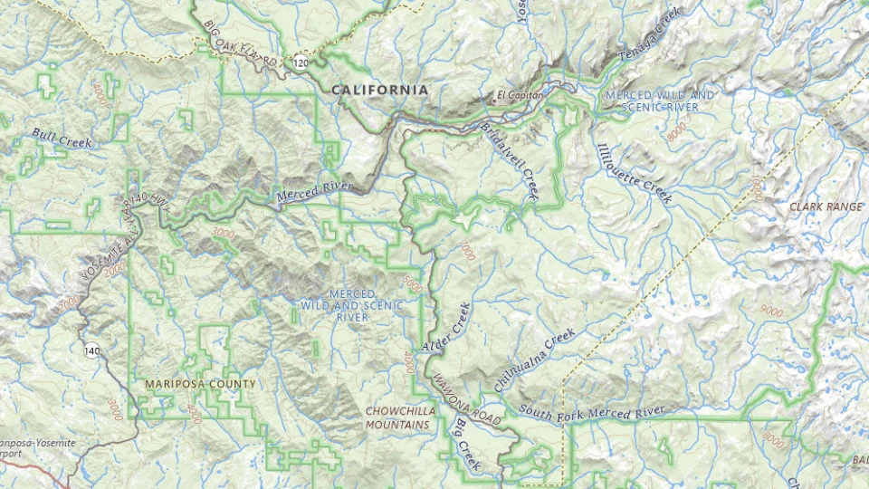
- Yosemite Valley
- El Portal / Highway 140
- Wawona / South entrance
Map sources and credits
USGS The National Map: National Boundaries Dataset, 3DEP Elevation Program, Geographic Names Information System, National Hydrography Dataset, National Land Cover Database, National Structures Dataset, and National Transportation Dataset; USGS Global Ecosystems; U.S. Census Bureau TIGER/Line data; USFS Road data; Natural Earth Data; U.S. Department of State HIU; NOAA National Centers for Environmental Information. Data refreshed September 4, 2026-v1.2
Original map service| Area | Choose it for | Tradeoff |
|---|---|---|
| Yosemite Valley | Early and late Valley time with less commuting. | Availability and room types can be limited. |
| El Portal / Highway 140 | A base on the western approach to the Valley. | You still have an entrance and a drive before the day begins. |
| Wawona / South entrance | Southern Yosemite and giant-sequoia outings. | Daily Valley visits require more driving. |
A sensible first visit
- Spend the arrival afternoon in the Valley with a short walk.
- Choose one substantial Valley outing and leave time for quiet stops.
- Add the grove or high country according to road access, rather than attempting both in one day.
Choose the activities that fit
Valley floor walks
A first visit focused on cliffs, meadows and short walks. Waterfall flow and path access vary with season and conditions.
Half to full day · Self-guided
Check valley floor walks detailsMariposa Grove
Visitors who want giant sequoias as part of the trip. Shuttle service and trail conditions change seasonally.
A separate half day or more · Shuttle and walking when operating
Check mariposa grove detailsHigh-country day
A longer stay during the high-road season. This is not a dependable winter itinerary and may be affected by other closures.
Full day if access permits · Self-drive and selected walks
Check high-country day detailsBefore you book
Check the official visitor information for current access, booking requirements and restrictions in Yosemite National Park before choosing dates or paying. The previous operational note is awaiting a fresh review.Road openings, fire restrictions and entry arrangements can change. Check the official conditions page before committing to Tioga Road, Glacier Point Road or a long hike. Never rely on a route planner alone for a seasonal crossing.
A second landscape depends on the road that reaches it
Tuolumne Meadows gives a different high-country setting when the relevant roads and facilities are available. Glacier Point is another approach with its own current conditions. Plan each approach from the current road information; the high-country outing may need a different day from Valley sightseeing.
Keep the existing Glacier Point closure guidance with the itinerary until an actual change is verified. If the higher outing is unavailable, a second Valley day or another officially accessible area is a useful replacement. Do not build a paid activity around presumed seasonal reopening.

The entrance journey is part of the accommodation choice
A Valley stay, when operating, can reduce repeated approaches. Rush Creek or Evergreen gives another lodge-and-cabin setting outside the park. Compare the actual route from that room to the chosen Valley outing rather than the distance to the first park boundary.
For two or three days, use one base and keep the major outdoor outing beside it. Confirm the current entry rules, road conditions and lodging product separately. A lodging reservation should not be presented as universal permission for every park road or activity.

A short day in Yosemite Valley
Use allowed valley roads and the current shuttle information; check entry conditions first.
Allow roughly half a day, plus arrival and a meal. The times below are planning estimates; opening hours, reservations and current conditions need a separate check.
Yosemite Valley Visitor Center
45–60 min · Start with current valley and trail information.
Lower Yosemite Fall area
45–60 min · Choose a short viewpoint outing; water flow is seasonal and never promised.
Sentinel Bridge, Yosemite
30–45 min · Finish with a valley view rather than adding Glacier Point driving time.
- Rest and lunch
- Carry a picnic and use a permitted rest area; wildlife must not get access to food.
- If the plan changes
- Stay with visitor-center and museum stops when weather or a closure rules out the walk.
- Access check
- Check the specific Lower Yosemite Fall route and current shuttle access with NPS; not every approach has the same surface.
What to plan next
Sources and planning checks
Research-based guidance, with editorial judgments about pace and location. Check the official provider for current access, prices and booking terms.
- NPS Yosemite maps and districts — Entrances, Valley, Wawona and high-road geography. Reviewed 2026-10-06.
- NPS: Yosemite current conditions — Road, trail and facility conditions; no reopening inferred from an old gallery. Reviewed 2026-10-08.
- NPS: Yosemite trip planning — Valley geography, traffic and official planning resources. Reviewed 2026-10-08.

