
In this guide
A two- or three-day park plan with a correctly located overnight base.
All topics and planning links
Match the outing to your access needs
Use the named park’s official accessibility information and ask about the exact surface, slope, distance and transport you need.NPS park websites provide information about accessible features, programs and services. Use the named park’s information to check surface, slope, distance and transport for the outing you actually choose.Checked 2026-10-07 · Source
Three park days that should not be one long drive
Cades Cove is a valley-and-history visit with an eleven-mile one-way loop. Newfound Gap and Kuwohi make a high-elevation version, where the journey and weather change the day. Oconaluftee sits on the North Carolina gateway near Cherokee, with another cultural and landscape context.
Choose one as the first full day, another as the second, and leave the third for a suitable forest outing or the visit displaced by weather. Townsend, Gatlinburg and Cherokee are useful for different starts. The best-known hotel town is not automatically the closest base for your chosen park day.

Start with this decision
Gatlinburg works for Sugarlands and town evenings. Townsend is a logical base for Cades Cove. Cherokee puts Oconaluftee and the North Carolina side first. Pick the side that matches most of your days.
- Suggested stay
- Choose the nights around your arrival, departure and selected outings.3–5 daysPlanning estimate · reviewed 2026-10-06 · Source
- Getting around
- Check the actual route and current transport for the dates and base you choose.Usually useful; choose one side of the park to reduce repeated crossing.Planning estimate · reviewed 2026-10-06 · Source
- When to go
- Check the intended season, official access and local conditions before booking.Spring flowers, summer shade or fall color; higher roads have their own weather.Planning estimate · reviewed 2026-10-06 · Source
Spend a day in a single part of the park. An 11-mile scenic loop can take far longer than its mileage suggests once traffic, wildlife and stops are included. Leave at least one optional activity out of the booked schedule.
Choose your base
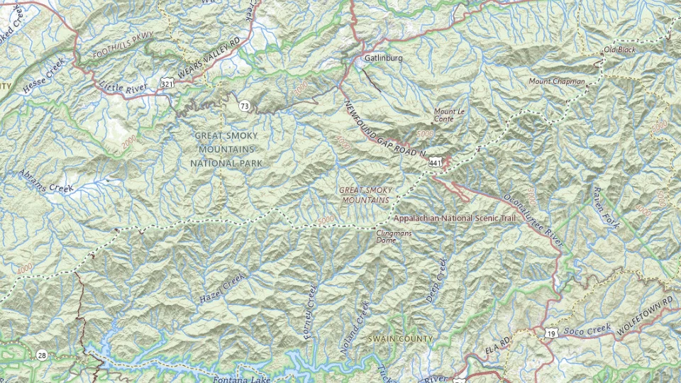
- Gatlinburg
- Townsend
- Cherokee
Map sources and credits
USGS The National Map: National Boundaries Dataset, 3DEP Elevation Program, Geographic Names Information System, National Hydrography Dataset, National Land Cover Database, National Structures Dataset, and National Transportation Dataset; USGS Global Ecosystems; U.S. Census Bureau TIGER/Line data; USFS Road data; Natural Earth Data; U.S. Department of State HIU; NOAA National Centers for Environmental Information. Data refreshed September 4, 2026-v1.2
Original map service| Area | Choose it for | Tradeoff |
|---|---|---|
| Gatlinburg | Sugarlands access and restaurants after a park day. | Traffic on the town approaches can slow the morning. |
| Townsend | Cades Cove and quieter evenings on the Tennessee side. | Fewer town attractions; a car does most of the work. |
| Cherokee | Oconaluftee and the North Carolina side. | The Tennessee attractions require a separate drive over or around the mountains. |
A sensible first visit
- Get oriented on your chosen side: Sugarlands from Gatlinburg or Oconaluftee from Cherokee.
- Use a full day for Cades Cove or a trail suited to your group.
- Keep a high-elevation outing flexible, with a lower-valley alternative if the weather closes in.
Choose the activities that fit
Cades Cove loop
Historic buildings and a valley landscape. Wildlife sightings are never guaranteed; traffic can move slowly.
Half to full day · Scenic drive with short walks
Check cades cove loop detailsOconaluftee
A short first park visit and interpretation of mountain history. Do not approach elk or build a schedule around seeing them.
A few hours · Self-guided or ranger-led
Check oconaluftee detailsKuwohi and Newfound Gap
High-elevation views on a clear day. Fog and cold can make the summit a poor use of the day; the climb is not a flat stroll.
A flexible half day · Scenic drive and optional walk
Check kuwohi and newfound gap detailsBefore you book
Check the official visitor information for current access, booking requirements and restrictions in Great Smoky Mountains before choosing dates or paying. The previous operational note is awaiting a fresh review.A parking tag is required when parking for longer than 15 minutes. It does not reserve a space. Road closures, wildlife restrictions and weather may change access; check current park notices before leaving your base.
Oconaluftee shows how people lived in this landscape
The Mountain Farm Museum behind Oconaluftee Visitor Center brings together historic Appalachian farm buildings. Most were moved from other parts of the park in the 1950s; the Davis House, barn and smaller working structures help explain a landscape that can otherwise become a collection of scenic stops.
Use the farm and visitor center as the main history interval on the Cherokee side, followed by a suitable nearby river outing. This fits a North Carolina approach more naturally than adding a cross-park transfer from a Cades Cove day. The paths at the farm are hard-packed gravel and NPS does not classify them as ADA accessible. Check the detailed accessibility page for the party’s needs before choosing a walk.

A short visit can still show more than a roadside view
Deep Creek offers a stream-and-waterfall area near Bryson City; Elkmont and Metcalf Bottoms offer forest, streams and historic context on another side of the park. Pick the area that belongs beside the overnight base, then use the official trail information for a walk the group can complete.
Children, a stroller and someone who avoids uneven ground need different route choices. A visitor-center or historic-building interval can be worthwhile even when a trail is unsuitable. Confirm the exact site’s access; a generally accessible park service does not establish every path is step-free.

What the season and parking tag change
The park’s changing elevations mean a comfortable gateway forecast can coexist with difficult high-country conditions. Use current road and trail notices before a mountain day. Kuwohi is the current name in NPS visitor information; older guides may still use Clingmans Dome.
Vehicles parked longer than fifteen minutes require a valid parking tag. It is a parking requirement, not a guaranteed space or a timed-entry reservation. Keep the current conditions link with the itinerary and preserve a lower-elevation alternative when the higher route cannot be used.
A short day in Sugarlands and a short Gatlinburg-side park visit
Car or a confirmed private transfer; do not assume the town trolley reaches these stops.
Allow roughly half a day, plus arrival and a meal. The times below are planning estimates; opening hours, reservations and current conditions need a separate check.
Sugarlands Visitor Center
45–60 min · Check current park information before choosing a walk.
Sugarlands Valley Nature Trail
45–60 min · Use a short near-road outing after checking the current trail and access information.
Sugarlands Visitor Center
30–45 min · Return to the visitor-center area, review conditions and end the short visit rather than adding a cross-park drive.
- Rest and lunch
- Carry water and a packed snack; use an authorized rest area and pack out litter.
- If the plan changes
- Stay with the visitor-center visit if weather, surfaces or a closure make the walk unsuitable.
- Access check
- Confirm trail surfaces, accessible facilities and current alerts with NPS. A parking place near a trail does not guarantee access.
What to plan next
Sources and planning checks
Research-based guidance, with editorial judgments about pace and location. Check the official provider for current access, prices and booking terms.
- NPS: Smokies areas and visit planning — Cades Cove, Oconaluftee, Deep Creek, Kuwohi and parking tags. Reviewed 2026-10-08.
- NPS: Smokies current conditions — Road, trail and seasonal access notices. Reviewed 2026-10-08.
- NPS Smokies parking tags — parking tags, entrance-pass distinction and display rules. Reviewed 2026-10-07.
- NPS Smokies pets — the two trails that permit leashed pets. Reviewed 2026-10-07.
- NPS: Mountain Farm Museum — Farm buildings, relocation history and location behind Oconaluftee Visitor Center. Reviewed 2026-10-10.
- NPS: Great Smoky Mountains accessibility — Mountain Farm Museum hard-packed gravel paths and NPS accessibility classification. Reviewed 2026-10-10.

