In this guide
Choose usable Parkway segments and a Smokies gateway without assuming an uninterrupted scenic drive.
All topics and planning links
Your working day-by-day plan
Eight days, seven nights: two Asheville-area nights, two on the North Carolina Smokies side and three in the chosen Tennessee gateway. Parkway through access is never assumed.
8 days · 7 nights · checked 2026-10-09
Local time: North Carolina and Tennessee gateways in this route: Eastern Time.
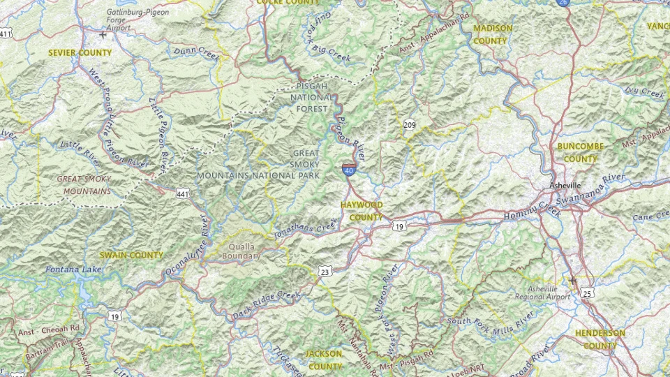
- Asheville · Location source
- Cherokee · Location source
- Gatlinburg · Location source
Map sources and credits
USGS The National Map: National Boundaries Dataset, 3DEP Elevation Program, Geographic Names Information System, National Hydrography Dataset, National Land Cover Database, National Structures Dataset, and National Transportation Dataset; USGS Global Ecosystems; U.S. Census Bureau TIGER/Line data; USFS Road data; Natural Earth Data; U.S. Department of State HIU; NOAA National Centers for Environmental Information. Data refreshed September 4, 2026-v1.2
Original map serviceDay 1 · Asheville
Start with Asheville’s downtown

Settle into Asheville and use the remaining day for a compact downtown walk and meal. Check official Blue Ridge Parkway road notices before choosing tomorrow’s scenic drive. A useful city base gives the route a beginning even if weather or storm damage removes a planned mountain segment.
- Transfer allowance
- 1–2 h
- Visits and walks
- 1–3 h
- Meals, parking & margin
- 1.5–2 h
- Selected stops
- Asheville
- Overnight
- Asheville area
If the plan changes: Keep a recovery interval instead of an added mountain drive.
Day 2 · Asheville
One open Blue Ridge outing from Asheville
Choose an officially open Parkway segment and one suitable viewpoint or walk rather than assuming the whole scenic road is available. Turn back from the same usable access point if needed. Keep Asheville’s local options as the fallback so a closure does not force an improvised long drive.
- Transfer allowance
- 1–2.5 h
- Visits and walks
- 3–4 h
- Meals, parking & margin
- 1.5–2 h
- Selected stops
- Asheville
- Overnight
- Asheville area
- Confirm first
- Check open Parkway segments
If the plan changes: Use an Asheville-area day if the intended Parkway segment is unavailable.
Day 3 · Cherokee
Move to Cherokee and the North Carolina gateway

Reach Cherokee by the currently operating road route. Resolve tomorrow’s park access and spend the remaining time on the gateway and a short suitable local outing. Keep any cross-park scenic drive separate from today’s arrival task; the first mountain evening should not require another long transfer.
- Transfer allowance
- 1.5–3 h
- Visits and walks
- 2–3 h
- Meals, parking & margin
- 1.5–2 h
- Selected stops
- Cherokee
- Overnight
- Cherokee area
- Confirm first
- Check open Parkway segments
If the plan changes: Take the confirmed main-road alternative; do not follow an assumed Parkway link.
Day 4 · Cherokee
Oconaluftee and a North Carolina-side park day

Begin with the Oconaluftee area, then choose an available nearby walk or scenic outing from the park’s current information. Keep the day concentrated on this side so there is time to stop and understand the landscape. For a dog, use the explicitly permitted Oconaluftee River Trail rather than assuming every park trail is open to pets.
- Transfer allowance
- 1–2 h
- Visits and walks
- 3–5 h
- Meals, parking & margin
- 1.5–2 h
- Selected stops
- Cherokee
- Overnight
- Cherokee area
- Confirm first
- Check the named Smokies areas
If the plan changes: Use an open shorter visitor-area option.
Day 5 · Gatlinburg
Cross to the Tennessee gateway only when access permits

Move to Gatlinburg using an officially available connection. If the planned park crossing is closed, compare the real outside-park route and decide whether another overnight is needed. After arrival, use the town for dinner and supplies, keeping the next park visit for a full day.
- Transfer allowance
- 1.5–3 h
- Visits and walks
- 1–2 h
- Meals, parking & margin
- 1.5–2 h
- Selected stops
- Gatlinburg
- Overnight
- Gatlinburg or Townsend
- Confirm first
- Check the named Smokies areas
If the plan changes: Use the verified alternative road and shorten the optional afternoon.
Day 6 · Gatlinburg
Choose Cades Cove or another single park area

Use the current park map and road notices to choose one Tennessee-side area, such as Cades Cove when its access works. A loop drive, parking and a short walk are enough to fill the main interval. Avoid treating several mountain areas as nearby attractions just because they share the same park boundary.
- Transfer allowance
- 1–2.5 h
- Visits and walks
- 3–4 h
- Meals, parking & margin
- 1.5–2 h
- Selected stops
- Gatlinburg
- Overnight
- Gatlinburg or Townsend
If the plan changes: Keep a nearby open alternative rather than adding a cross-park detour.
Day 7 · Gatlinburg
Keep a weather day, or enjoy Gatlinburg

Replace the outdoor visit that poor conditions displaced, or use the day for the gateway town and a shorter outing. Check the actual operating details before booking an attraction. The spare interval can protect the park experience while leaving an easier evening before the departure drive.
- Transfer allowance
- 0.5–1.5 h
- Visits and walks
- 3–5 h
- Meals, parking & margin
- 1.5–2 h
- Selected stops
- Gatlinburg
- Overnight
- Gatlinburg or Townsend
If the plan changes: Use a named indoor interest or a rest day.
Day 8 · Gatlinburg
Leave from your actual Smokies gateway

Work backward from the booked airport or road destination. Asheville and the Tennessee side produce different final routes, and a park crossing is not guaranteed transport. Choose the confirmed road, allow a meal and vehicle handover where needed, and leave the mountain detour for another trip if time is tight.
- Transfer allowance
- 1–4 h
- Visits and walks
- 0–1 h
- Meals, parking & margin
- 1.5–2 h
- Selected stops
- Gatlinburg
- Overnight
- No night included after this day; protect the actual onward connection.
If the plan changes: Add an overnight if the departure requires a longer drive.
What to resolve before paying
- Check open Parkway segments
- Check the named Smokies areas
- Reserve three useful bases — after steps 1 and 2
All time bands are planning estimates, not measured drives, timetables or operator promises. They exclude flight time and overnight sleep. Check live navigation, official access, your group’s needs and the actual booking.
Your choices at a glance
| Stage | Suggested nights | Planning rule |
|---|---|---|
| Asheville area | 2 | Choose open Parkway segments as outings |
| Cherokee / North Carolina Smokies | 2 | Group nearby valleys and cultural stops |
| Gatlinburg or Townsend | 2–3 | Pick the gateway for your park priorities |
Durations and driving allowances are planning estimates, not live navigation. Check the route, weather and access before travel; add time for stops, queues and traffic.
A mountain road is a place to spend time
Use Asheville as a town-and-mountain base rather than a quick fuel stop. A Parkway segment, a selected short walk and an evening in town make a coherent day. Keep the Smokies stay in one gateway for the park outings it supports: Townsend for the Cades Cove side, Cherokee for Oconaluftee, or Gatlinburg for its town and the north-side approach.
The Parkway is a scenic road, not the fastest connection between all these bases. Driving every available mile can crowd out the reason for going. Choose two or three scenic intervals with usable trailheads or overlooks, then use a practical main-road connection for the rest. A closure may remove a segment without removing the town or the entire holiday.
Build the rainy day in the same gateway
Fog can hide a viewpoint even when a road is open. Heavy rain, wind and winter conditions create a separate access question. Keep an Asheville town day or a shorter gateway outing available instead of repeatedly driving uphill in search of the advertised view. During a foliage trip, differing elevations can mean different stages of color; there is no guaranteed peak day across the whole route.
Check NPS Parkway closures and the Smokies road pages independently. Add fuel and meal stops before the quiet sections and protect daylight for the mountain drive. In the Smokies, the parking tag does not reserve a space or replace a trail’s suitability check. Budget it alongside accommodation and parking elsewhere, without calling the park visit a wholly free outing.
Check closures by milepost
NPS reports Parkway access by road section and milepost. Read the closure table and map for every intended connection; a general statement that the Parkway is open does not mean your whole route is open.
Use ordinary highways to bypass closed sections. Recalculate the day before booking a timed attraction or committing to a remote accommodation arrival.
Choose the Smokies side deliberately
Cherokee suits Oconaluftee and the North Carolina approach. Gatlinburg suits Sugarlands and town attractions. Townsend suits a slower stay nearer Cades Cove. Crossing the park repeatedly is rarely the best use of a short stay.
Check Newfound Gap Road separately from the Parkway. The parking-tag requirement in the Smokies is also separate from any accommodation parking.
What to plan next
Sources and planning checks
Research-based guidance, with editorial judgments about pace and location. Check the official provider for current access, prices and booking terms.
- NPS Blue Ridge Parkway closures — Section-by-section access and detours. Reviewed 2026-10-06.
- NPS Smokies planning — Gateway and park-area geography. Reviewed 2026-10-06.
