
In this guide
A Bear Lake-area day and a separately assessed high-country outing.
All topics and planning links
Match the outing to your access needs
Use the named park’s official accessibility information and ask about the exact surface, slope, distance and transport you need.NPS park websites provide information about accessible features, programs and services. Use the named park’s information to check surface, slope, distance and transport for the outing you actually choose.Checked 2026-10-07 · Source
Start with the actual Bear Lake route
Bear Lake is a useful east-side landmark, but the suitable outing depends on the route, surface and conditions. Use the official corridor information to choose a short visit or a longer walk for the actual party. If steps or snow would prevent the visit, check the specific route’s current surface and access information first.
Estes Park supplies an east-side base with its own journey to the park. Keep the first morning’s entry product and transport arrangement with the accommodation decision. During the applicable season, the corridor and other park access can involve different reservation choices.

Start with this decision
Estes Park suits the eastern side and Bear Lake corridor. Grand Lake suits the west. Trail Ridge Road links them only when conditions permit; the two bases are not interchangeable throughout the year.
- Suggested stay
- Choose the nights around your arrival, departure and selected outings.3–4 daysPlanning estimate · reviewed 2026-10-06 · Source
- Getting around
- Check the actual route and current transport for the dates and base you choose.Useful for arrival; seasonal shuttles help on selected routes.Planning estimate · reviewed 2026-10-06 · Source
- When to go
- Check the intended season, official access and local conditions before booking.High-road access is seasonal; lower trails and winter visits need different plans.Planning estimate · reviewed 2026-10-06 · Source
Start with a gentler outing and keep exposed, high-elevation plans early and weather-aware. Use a separate day for a scenic-road crossing instead of adding it after a demanding hike.
Choose your base
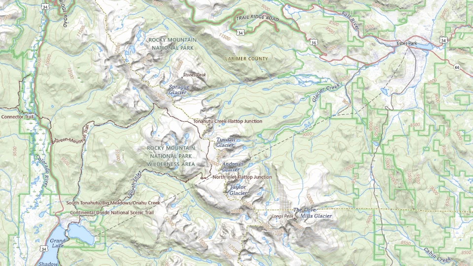
- Estes Park
- Grand Lake
Map sources and credits
USGS The National Map: National Boundaries Dataset, 3DEP Elevation Program, Geographic Names Information System, National Hydrography Dataset, National Land Cover Database, National Structures Dataset, and National Transportation Dataset; USGS Global Ecosystems; U.S. Census Bureau TIGER/Line data; USFS Road data; Natural Earth Data; U.S. Department of State HIU; NOAA National Centers for Environmental Information. Data refreshed September 4, 2026-v1.2
Original map service| Area | Choose it for | Tradeoff |
|---|---|---|
| Estes Park | Eastern entrances and Bear Lake plans. | Busy periods can affect roads and parking. |
| Grand Lake | The western side and a lake-town stay. | An east-side itinerary can mean a seasonal mountain crossing. |
A sensible first visit
- Start with a gentler outing close to the chosen entrance.
- Give the Bear Lake area a separate day with the correct access arrangements.
- Use a clear-weather day for Trail Ridge Road if open, with a lower-elevation alternative.
Choose the activities that fit
Bear Lake corridor
A first selection of lake and mountain scenery. Trail difficulty and altitude vary beyond the first lake.
Half to full day · Walks and seasonal shuttle
Check bear lake corridor detailsTrail Ridge Road
A high-country day when the road is open. Snow, wind and sudden closures can alter the trip.
A full flexible day · Scenic drive
Check trail ridge road detailsBefore you book
Check the official visitor information for current access, booking requirements and restrictions in Rocky Mountain National Park before choosing dates or paying. The previous operational note is awaiting a fresh review.Timed-entry options can distinguish the Bear Lake corridor from the rest of the park. Check the exact reservation, date and access window, plus current road conditions.
Trail Ridge is a seasonal crossing, not a guaranteed shortcut
A high-country drive gives another landscape when the relevant road and facilities are available. Use the current NPS road status before building a cross-park itinerary. Winter and shoulder-season closures can change the whole overnight sequence.
Altitude, weather and the actual walking commitment need preparation even on a trip described as scenic driving. Choose a suitable short interval and leave a lower-elevation alternative. The Alpine Visitor Center outing depends on the current mountain-road access, so keep the lower-area day ready until that is confirmed.

Keep the first visit on one practical side
For two or three days, a focused east-side stay can provide a complete park visit without a planned crossing. Add a west-side region only when it supplies real days and confirmed transport, rather than using it as another name on the map.
Check the current entry and corridor requirements, park pass eligibility and lodging independently. Keep a flexible interval when weather displaces the high-country outing. The exact trail and road sources define the visit, while the duration on this guide is an editorial planning estimate.

A short day in The Beaver Meadows side of the park
Car or an appropriate confirmed tour; check entry reservations, road conditions and season.
Allow roughly half a day, plus arrival and a meal. The times below are planning estimates; opening hours, reservations and current conditions need a separate check.
Beaver Meadows Visitor Center
30–45 min · Start with current park access and weather information.
Moraine Park, Rocky Mountain National Park
45–60 min · Choose a short authorized viewpoint or walk, avoiding wildlife approaches.
Beaver Meadows Visitor Center
30–45 min · Return without adding a high-elevation road excursion to the short visit.
- Rest and lunch
- Carry water and take a rest; allow extra room for how altitude affects the group.
- If the plan changes
- Keep the visitor-center visit and an Estes Park outing when weather or entry restrictions change the plan.
- Access check
- Ask NPS about the exact selected trail or viewpoint, facilities and surfaces; altitude suitability is an individual question.
What to plan next
Sources and planning checks
Research-based guidance, with editorial judgments about pace and location. Check the official provider for current access, prices and booking terms.
- NPS: Rocky Mountain roads — Road and seasonal crossing status. Reviewed 2026-10-08.
- NPS: Bear Lake Road corridor — Corridor geography and current transport information. Reviewed 2026-10-08.
- NPS Rocky Mountain timed entry — reservation types and Bear Lake Road access. Reviewed 2026-10-07.
- NPS: Rocky Mountain planning — Seasonal entry, park areas and official trip resources. Reviewed 2026-10-08.

