
In this guide
A canyon day plus a separately chosen second day, with permits and transport distinguished.
All topics and planning links
Entry, shuttle and activity checks
Confirm entry, the current shuttle timetable and any separate activity requirement with NPS before travel.NPS currently requires no advance reservation to enter Zion or ride the park shuttle. Named activities have their own requirements; confirm the operating timetable for your dates.Checked 2026-10-07 · Source
Check the current NPS entry products, party eligibility and residency rules. No universal entrance total is quoted here.An entrance fee or eligible pass is separate from a shuttle reservation, lodging or a named activity. Check the entry product, residency rules and any additional fee that applies to your party.Checked 2026-10-07 · Source
Match the outing to your access needs
Use the named park’s official accessibility information and ask about the exact surface, slope, distance and transport you need.NPS park websites provide information about accessible features, programs and services. Use the named park’s information to check surface, slope, distance and transport for the outing you actually choose.Checked 2026-10-07 · Source
A complete canyon day without a river hike
Use the operating canyon shuttle to reach Temple of Sinawava, then make Riverside Walk the destination. Its end is a useful decision point: turning back gives you a dry outing; continuing upstream means entering The Narrows and accepting a different conditions, clothing and equipment problem.
Leave time for shuttle queues, the return and selected canyon stops such as the Court of the Patriarchs. For a first visit, this day shows the canyon without requiring a permit-dependent exposed hike or a river crossing. Add a Springdale evening instead of a second park on the same day.

Start with this decision
Choose Springdale for a first visit built around Zion Canyon. Choose the east side for a quieter base and east-side scenery, accepting a drive to the main visitor center. Two nights beat a rushed stop between Las Vegas and Bryce.
- Suggested stay
- Choose the nights around your arrival, departure and selected outings.2–3 daysPlanning estimate · reviewed 2026-10-06 · Source
- Getting around
- Check the actual route and current transport for the dates and base you choose.Useful to reach the park; the canyon shuttle handles many trailheads in its operating season.Planning estimate · reviewed 2026-10-06 · Source
- When to go
- Check the intended season, official access and local conditions before booking.Spring and fall for lower-elevation walks; conditions matter more than the month.Planning estimate · reviewed 2026-10-06 · Source
Put the longest walk early in the day, then leave the afternoon for the museum, an easy riverside section, or Springdale. A shuttle ride and a trail are separate time commitments; do not schedule them as if the parking lot were the trailhead.
Choose your base
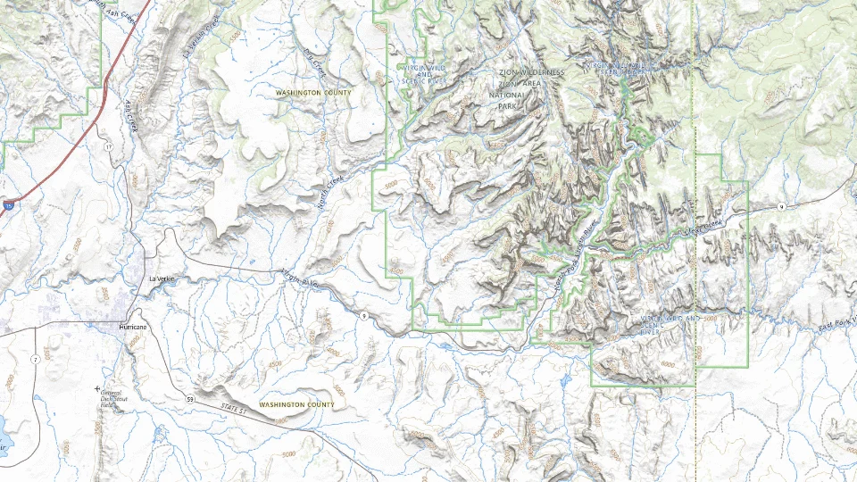
- Springdale
- East entrance area
- Hurricane / La Verkin
Map sources and credits
USGS The National Map: National Boundaries Dataset, 3DEP Elevation Program, Geographic Names Information System, National Hydrography Dataset, National Land Cover Database, National Structures Dataset, and National Transportation Dataset; USGS Global Ecosystems; U.S. Census Bureau TIGER/Line data; USFS Road data; Natural Earth Data; U.S. Department of State HIU; NOAA National Centers for Environmental Information. Data refreshed September 4, 2026-v1.2
Original map service| Area | Choose it for | Tradeoff |
|---|---|---|
| Springdale | Walking to restaurants and access to the main canyon. | Convenience can cost more; a Springdale address does not mean the entrance is walkable. |
| East entrance area | East-side scenery and cabin-style stays. | You cross the park to reach the main canyon; road restrictions can change the journey. |
| Hurricane / La Verkin | More services and a base for several southwest Utah stops. | Daily driving replaces the convenience of staying at the canyon. |
A sensible first visit
- Arrive, check current conditions at the visitor center, then make a short Pa’rus outing.
- Use the canyon shuttle for Riverside Walk and one additional stop; keep a substantial gap for queues and lunch.
- Add a longer hike only if permits and conditions fit. Otherwise use the east-side viewpoints as a separate outing.
Choose the activities that fit
Riverside Walk
A first look at the canyon without committing to a river hike. The paved route is still exposed to weather and may have access restrictions.
Allow a half day with transport · Self-guided; use a ranger program for interpretation
Check riverside walk detailsThe Narrows, bottom up
Travelers prepared to walk in cold, moving water. It is not an all-weather substitute for a dry trail, and conditions can rule it out completely.
Reserve a full flexible day · Self-guided river hike; specialist outfitting is separate
Check the narrows, bottom up detailsPa’rus Trail and canyon viewpoints
An easier day, mixed walking abilities and a route that can be shortened. Shade is limited on sections; check the park’s accessibility information for your needs.
A flexible morning or afternoon · Self-guided
Check pa’rus trail and canyon viewpoints detailsBefore you book
Check the official visitor information for current access, booking requirements and restrictions in Zion National Park before choosing dates or paying. The previous operational note is awaiting a fresh review.Angels Landing beyond Scout Lookout requires a permit. The Narrows depends on flow, weather and health advisories. A general park visit and the canyon shuttle do not require an entry reservation; check the park for your exact activity.
The Narrows and Angels Landing are different commitments
Choose The Narrows when a river hike is the experience you want and the current flow, forecast and advisories make your proposed outing suitable. Choose Angels Landing only with the required permit and a party prepared for its exposed terrain. A permit does not establish that a route is suitable for every person in the group.
A shorter canyon day is a complete alternative if either main outing is unavailable. Use the official trail descriptions for surface, distance and access instead of treating a famous name as the minimum worthwhile Zion visit. Keep a flexible day before moving the overnight base.

Driving east needs a vehicle decision
The Zion–Mt. Carmel road is a scenic connection, but it is not a route every RV or trailer can use. Measure the actual rental vehicle with its attachments before building a Bryce transfer around it. The relevant restriction applies to the highway section, not simply the tunnel opening.
Use the official alternatives when the vehicle cannot transit. The detour changes the transfer day; remove an extra hike rather than trying to preserve the old schedule. The shared notice below expires into a current-rule check if it has not been reviewed.
Check the current NPS vehicle dimensions, affected highway section, exceptions and alternative routes before taking an RV or trailer through Zion. No current transit permission is confirmed here.NPS applies vehicle limits between Canyon Junction and the East Entrance. A single vehicle must not exceed 35 ft 9 in long, 7 ft 10 in wide, 11 ft 4 in high or 50,000 lb. Combined vehicles have a 50 ft total-length limit and a 26 ft hitch-to-rear-axle trailer limit, with the same width, height and weight limits. Measurements include mirrors and attachments; read the South Entrance exceptions and alternative routes before booking an RV journey.Checked 2026-10-08 · Source

A short day in Springdale and the lower canyon
Walk or use the current town/park shuttle arrangements; check operating dates.
Allow roughly half a day, plus arrival and a meal. The times below are planning estimates; opening hours, reservations and current conditions need a separate check.
Zion Canyon Visitor Center
30–45 min · Check shuttle, weather and access information before entering the canyon.
Pa’rus Trail, Zion
60–90 min · Choose a manageable out-and-back section and turn around when the group has had enough.
Zion Canyon Visitor Center
30–45 min · Return to the same starting area rather than adding the Narrows to a short day.
- Rest and lunch
- Carry water and take a seated rest near the visitor-center area; summer shade is limited.
- If the plan changes
- Use a short visitor-center visit and Springdale indoor stops during unsafe heat, storms or trail closures.
- Access check
- Check NPS surface, restroom and shuttle information. This plan avoids slot-canyon water travel and does not establish personal suitability.
What to plan next
Sources and planning checks
Research-based guidance, with editorial judgments about pace and location. Check the official provider for current access, prices and booking terms.
- NPS: Zion visit planning — Entry, shuttle and separate activity requirements. Reviewed 2026-10-08.
- Visit Utah: Zion bases — Gateway towns and accommodation geography. Reviewed 2026-10-06.
- NPS Narrows planning — river-walking conditions, access and alternatives. Reviewed 2026-10-07.
- NPS: Zion large vehicles — Affected highway section, dimensions, exceptions and alternative routes. Reviewed 2026-10-08.


