
In this guide
Two or three local days with one main outdoor commitment per day.
All topics and planning links
Pick the landscape you want to spend time in
Cathedral Rock, the Chapel of the Holy Cross and Oak Creek give you different Sedona settings. A distant view of a formation is not the same outing as its hiking route. Choose the actual trail or viewpoint, current access and approach before filling the rest of the day.
A jeep tour can supply a guided landscape experience for someone who does not want the same hiking commitment, but ride conditions and participation requirements still matter. It is not automatically an accessible alternative for every traveler. Read the named product rather than deciding from the vehicle photograph.

Start with this decision
Uptown suits a first visit with restaurants close by. West Sedona makes errands and a longer stay easier. The Village of Oak Creek puts you near Bell Rock and Courthouse Butte, with a separate drive to Uptown.
- Suggested stay
- Choose the nights around your arrival, departure and selected outings.2–4 daysPlanning estimate · reviewed 2026-10-06 · Source
- Getting around
- Check the actual route and current transport for the dates and base you choose.Useful for the region; trailhead shuttles can replace some drives.Planning estimate · reviewed 2026-10-06 · Source
- When to go
- Check the intended season, official access and local conditions before booking.Spring and fall for walking; summer requires an early start and a heat-aware plan.Planning estimate · reviewed 2026-10-06 · Source
Walk early, reserve the middle of the day for galleries or a rest, and choose a sunset spot with a legal parking plan. A trailhead appearing close on a map does not mean it has available parking.
Choose your base
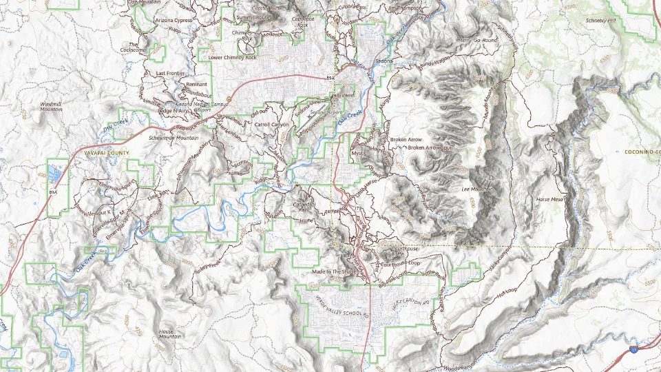
- Uptown
- West Sedona
- Village of Oak Creek
Map sources and credits
USGS The National Map: National Boundaries Dataset, 3DEP Elevation Program, Geographic Names Information System, National Hydrography Dataset, National Land Cover Database, National Structures Dataset, and National Transportation Dataset; USGS Global Ecosystems; U.S. Census Bureau TIGER/Line data; USFS Road data; Natural Earth Data; U.S. Department of State HIU; NOAA National Centers for Environmental Information. Data refreshed September 4, 2026-v1.2
Original map service| Area | Choose it for | Tradeoff |
|---|---|---|
| Uptown | A walkable concentration of restaurants, galleries and tour departures. | Traffic and visitor activity can make it a poor match for a secluded stay. |
| West Sedona | Grocery access and a practical base for several days. | A room on the main road may feel different from a creekside retreat. |
| Village of Oak Creek | Bell Rock country and a quieter alternative to Uptown. | You trade Uptown convenience for a separate base to the south. |
A sensible first visit
- Settle into one base and take a short red-rock walk nearby.
- Choose one longer morning trail, then galleries or a pool afternoon.
- Use the final morning for a contrasting landscape; avoid adding a distant trail before a long onward drive.
Choose the activities that fit
Bell Rock area
A flexible red-rock outing that can be shortened. Trails differ in difficulty; a walk around the area is not the same as climbing the rock.
Morning · Self-guided walk
Check bell rock area detailsA guided off-road excursion
Visitors who want backroad scenery without self-driving a rugged track. Ride intensity and seating vary; pregnancy, back or neck conditions may rule out a route.
Half day including check-in · Guided vehicle tour
Check a guided off-road excursion detailsTlaquepaque and Uptown galleries
A lower-effort afternoon between hikes. Outdoor courtyards still expose you to the weather.
Afternoon · Self-guided
Check tlaquepaque and uptown galleries detailsBefore you book
Check the official visitor information for current access, booking requirements and restrictions in Sedona before choosing dates or paying. The previous operational note is awaiting a fresh review.Check current shuttle requirements, parking passes and trail conditions. An off-road vehicle booking is not permission to drive any track; ask the operator about the exact route and road restrictions.
Oak Creek changes the holiday rhythm
Oak Creek Canyon and Slide Rock create a water-and-canyon version of the visit. Conditions, the selected activity and the exact access decide what is suitable. Do not turn a swimming photograph into a promise of safe water or an operating activity on the travel date.
A creek-led stay may favor another hotel location from an Uptown or Highway 179 trip. Put the chosen outdoor morning and the evening meal on the same plan. For a short visit, one local cluster leaves more time outside than driving between every named formation.

Make the quieter half of the day useful
After the main outing, keep time for the town’s galleries, a neighborhood meal or a view from a less demanding location. Tlaquepaque and the surrounding town context offer another texture from the trail. A rest interval is particularly useful when heat or walking has already used the group’s energy.
If Sedona is part of the Las Vegas–Grand Canyon route, use the arrival day for a local interval and keep the main outdoor outing beside the overnight base. Parking, shuttle arrangements where relevant and current trail status belong to the specific outing, not a generic Sedona pass assumption.

A short day in Uptown and nearby viewpoints
Car or a confirmed local transfer for the viewpoint; walk only the Uptown portion.
Allow roughly half a day, plus arrival and a meal. The times below are planning estimates; opening hours, reservations and current conditions need a separate check.
Sedona Uptown
45–60 min · Start with a short town visit and current visitor information.
Airport Mesa scenic viewpoint, Sedona
30–45 min · Use a viewpoint stop after checking parking and road access; this is not a summit-hiking plan.
Tlaquepaque Arts & Shopping Village
60–90 min · Finish in the shopping complex with time for lunch and shade.
- Rest and lunch
- Put a seated lunch at the final stop rather than eating during a hot trail walk.
- If the plan changes
- Keep the town and gallery visits when heat, storms or parking pressure make the viewpoint unsuitable.
- Access check
- Check the viewpoint path and each venue’s access information; rocky trails are not interchangeable with paved town routes.
What to plan next
Sources and planning checks
Research-based guidance, with editorial judgments about pace and location. Check the official provider for current access, prices and booking terms.
- Visit Sedona: accommodation areas — Uptown, West Sedona and Village of Oak Creek. Reviewed 2026-10-06.
- Visit Sedona: shopping districts — Tlaquepaque and district geography. Reviewed 2026-10-06.
- Visit Sedona: activities and local planning — Outdoor, cultural and local transport planning categories. Reviewed 2026-10-08.


