
In this guide
A booked island visit or waterfront alternative and a separately chosen park day.
All topics and planning links
Alcatraz needs the right ferry product
NPS identifies Alcatraz City Cruises as the contracted ferry to the island. Choose the actual landing visit when the island’s history and exhibits are the priority. A bay cruise passing the island is another experience and should not be described as the same admission.
The island visit needs at least a substantial multi-hour interval, including the ferry and time ashore. Keep the next timed activity away from the return window. Read the selected access and visitor conditions before deciding the product suits the whole group.

Start with this decision
Union Square offers a central hotel district. Fisherman’s Wharf suits waterfront plans and a first visit. A neighborhood stay elsewhere works best when you actually want to spend time there.
- Suggested stay
- Choose the nights around your arrival, departure and selected outings.3–4 daysPlanning estimate · reviewed 2026-10-06 · Source
- Getting around
- Check the actual route and current transport for the dates and base you choose.Usually unnecessary in the city; collect one when a road trip begins.Planning estimate · reviewed 2026-10-06 · Source
- When to go
- Check the intended season, official access and local conditions before booking.Year-round city travel; layers matter even on a summer visit.Planning estimate · reviewed 2026-10-06 · Source
Group the waterfront with a ferry or island visit, and give Golden Gate Park or the Mission a separate block. A cable-car queue is part of the experience, but it should not be your only route to a timed ticket.
Choose your base
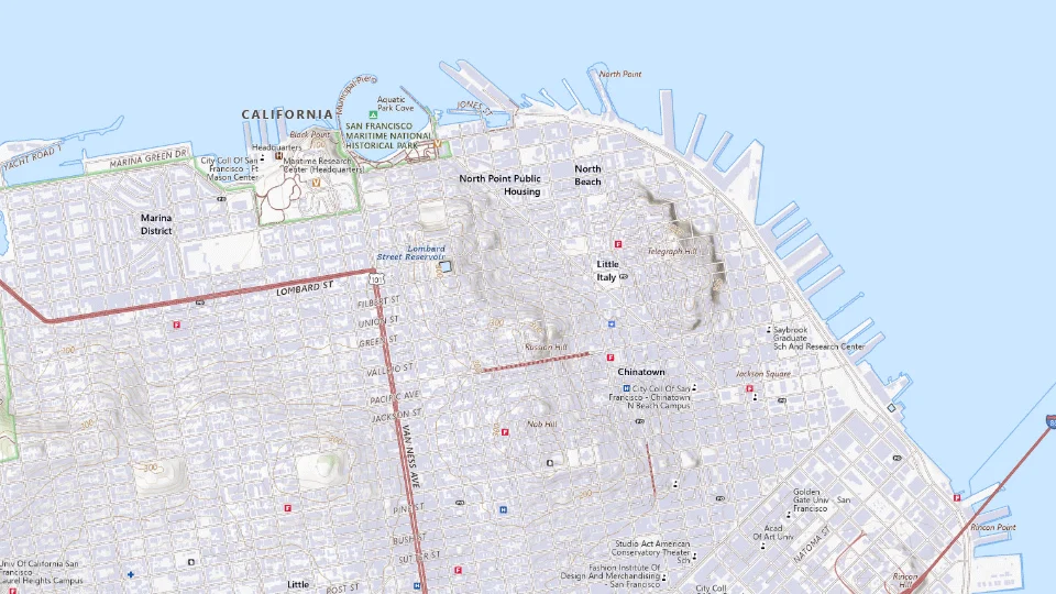
- Union Square
- Fisherman’s Wharf
Map sources and credits
USGS The National Map: National Boundaries Dataset, 3DEP Elevation Program, Geographic Names Information System, National Hydrography Dataset, National Land Cover Database, National Structures Dataset, and National Transportation Dataset; USGS Global Ecosystems; U.S. Census Bureau TIGER/Line data; USFS Road data; Natural Earth Data; U.S. Department of State HIU; NOAA National Centers for Environmental Information. Data refreshed September 4, 2026-v1.2
Original map service| Area | Choose it for | Tradeoff |
|---|---|---|
| Union Square | A central hotel base and transport connections. | Nearby blocks differ; inspect the precise arrival route. |
| Fisherman’s Wharf | Waterfront sights and a first visit. | A visitor-focused setting with separate trips to other neighborhoods. |
A sensible first visit
- Explore the waterfront and a selected neighborhood.
- Use the clearest weather for the bridge and keep a park or museum alternative.
- Give Alcatraz or another substantial visit its own half day.
Choose the activities that fit
Golden Gate viewpoints
A flexible outdoor highlight. Fog and wind can change visibility.
Half day · Self-guided
Check golden gate viewpoints detailsAlcatraz
History and a different view of the bay. Tickets and security require planning.
Half day or more · Ferry and historic-site visit
Check alcatraz detailsBefore you book
Check the official visitor information for current access, booking requirements and restrictions in San Francisco before choosing dates or paying. The previous operational note is awaiting a fresh review.Keep belongings out of an unattended vehicle, including during brief viewpoint stops. For Alcatraz, use the authorized ferry information and distinguish island admission from a cruise that only passes it.
Choose a second day with a different landscape
Golden Gate Park gives another city setting, with a chosen institution or public-space interval as the anchor. The Palace of Fine Arts and a Golden Gate viewpoint create another direction. Select a coherent cluster rather than connecting every famous photograph with a taxi ride.
San Francisco’s slopes matter on the walk and the luggage arrival. A place described as near the center can still involve a route that is difficult for the group. Confirm the actual transport and access instead of measuring only straight-line distance.

Start the road trip after the city stay
For a short San Francisco visit, compare using local transport with keeping a car through the city nights. Collect the coastal-road rental when it becomes useful where the booking allows, and include the actual pickup and parking quotes.
A first PCH night in Monterey is another trip day, not a city afternoon with a slightly longer drive. Check Highway 1 conditions before locking in the coastal route; the city and the road portion need compatible but separate plans.

A short day in The northeastern waterfront
Walk a manageable waterfront circuit; use transit for the arrival and return.
Allow roughly half a day, plus arrival and a meal. The times below are planning estimates; opening hours, reservations and current conditions need a separate check.
Ferry Building, San Francisco
45–60 min · Start with food stalls and the waterfront, checking individual vendor hours.
Exploratorium
90–120 min · Use the museum as the main paid visit rather than squeezing in another major attraction.
Pier 39, San Francisco
45–60 min · Continue along the waterfront if the group has enough energy; wildlife sightings are not guaranteed.
- Rest and lunch
- Have lunch near the museum and allow a seated rest before the final walk.
- If the plan changes
- Keep the museum and use transit back rather than a long exposed walk in wind or rain.
- Access check
- Confirm museum access and transit boarding; avoid assuming the city’s steep inland streets resemble the waterfront.
Arrive with a plan: SFO · San Francisco
Match the arrival route to the hotel’s actual neighborhood; an airport or suburban hotel is a different stay from downtown.
- Transit or a transfer
- SFO’s BART station is in the International Terminal. Compare BART and any AirTrain connection with a road transfer using current station and service information.
- Should you collect a car?
- Avoid paying for an idle car during a city-only stay. A later coastal road trip can begin with a separate pickup, subject to rental opening hours and terms.
- Before the first booking
- Consider hills and the walk from the station with luggage. Verify service for your arrival time rather than assuming rail runs all night.
Transport choices researched October 8, 2026. Current fares, departure times and accessible connections remain a check for your travel date.
What to plan next
Sources and planning checks
Research-based guidance, with editorial judgments about pace and location. Check the official provider for current access, prices and booking terms.
- San Francisco Travel neighborhoods — Neighborhood geography. Reviewed 2026-10-06.
- San Francisco Travel Union Square — Hotel district. Reviewed 2026-10-06.
- NPS: Alcatraz visit planning — Authorized island ferry, visit time and ticket planning. Reviewed 2026-10-08.

