
In this guide
A peninsula day and one deliberate harbor or outside-city outing.
All topics and planning links
Start with a small part of the historic city
Use the historic peninsula for a walking day around the buildings, streets and waterfront you want to understand. Rainbow Row and Waterfront Park give you recognizable places without making every stop a paid activity. Add one historical interior or guided explanation as the day’s anchor.
A history guide should make the city’s social and cultural context clearer, including whose story is being told. Choose a route that leaves time to look and ask questions. A quick photograph of a house is a different experience from understanding the people and labor behind it.

Start with this decision
Stay on the peninsula for a first city visit. Mount Pleasant can work for a mixed city-and-coast trip with a car. Folly Beach suits a beach holiday with one deliberate downtown day.
- Suggested stay
- Choose the nights around your arrival, departure and selected outings.3–4 daysPlanning estimate · reviewed 2026-10-06 · Source
- Getting around
- Check the actual route and current transport for the dates and base you choose.Optional for downtown; helpful for beaches and sites outside the peninsula.Planning estimate · reviewed 2026-10-06 · Source
- When to go
- Check the intended season, official access and local conditions before booking.Spring and fall for outdoor time; summer brings heat, humidity and storm risk.Planning estimate · reviewed 2026-10-06 · Source
Start with a walk on the peninsula, keep an indoor option for the hottest part of the day, and reserve only the meals or visits you care most about. A harbor boat trip adds a fixed departure and a weather dependency.
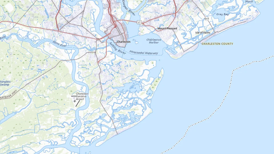
Choose your base
- Downtown peninsula
- Mount Pleasant
- Folly Beach
Map sources and credits
USGS The National Map: National Boundaries Dataset, 3DEP Elevation Program, Geographic Names Information System, National Hydrography Dataset, National Land Cover Database, National Structures Dataset, and National Transportation Dataset; USGS Global Ecosystems; U.S. Census Bureau TIGER/Line data; USFS Road data; Natural Earth Data; U.S. Department of State HIU; NOAA National Centers for Environmental Information. Data refreshed September 4, 2026-v1.2
Original map service| Area | Choose it for | Tradeoff |
|---|---|---|
| Downtown peninsula | Walking to historic streets, museums and restaurants. | Room rates and parking can be substantial; nightlife varies by block. |
| Mount Pleasant | A car-based mix of downtown, harbor and beach outings. | You exchange a walkable center for bridge crossings. |
| Folly Beach | A beach-first stay with a separate Charleston day. | Beach weather and traffic become part of the plan. |
A sensible first visit
- Explore downtown on foot and keep the arrival evening close to the hotel.
- Choose one substantial history visit or harbor outing, with time for a meal afterward.
- Add a beach day if the forecast fits; otherwise stay with museums and neighborhoods.
Choose the activities that fit
Historic downtown walk
A first visit centered on streets, architecture and public spaces. Heat and uneven paving affect the route.
Half day · Self-guided or guided history walk
Check historic downtown walk detailsFort Sumter visit
Visitors interested in Civil War history and harbor geography. Different docks are not interchangeable; weather may affect sailings.
Half day including check-in · Ferry and historic-site visit
Check fort sumter visit detailsA barrier-island beach day
A slower day beyond the historic center. You need to plan parking, sun exposure and swimming conditions.
Full or half day · Self-guided
Check a barrier-island beach day detailsBefore you book
Check the official visitor information for current access, booking requirements and restrictions in Charleston before choosing dates or paying. The previous operational note is awaiting a fresh review.Read historic-property access details and total parking charges. When choosing a plantation or historic-site visit, look for substantial interpretation of slavery and the people who lived and worked there.
Give the waterfront’s history time indoors
The International African American Museum stands at Gadsden’s Wharf, a place central to the arrival of enslaved Africans in Charleston. Its galleries connect that history with African American culture and the wider diaspora. The museum and its African Ancestors Memorial Garden add a necessary perspective to a trip otherwise centered on houses and harbor photographs.
Use the museum as the substantial visit in a waterfront day, then leave time to reflect and walk rather than scheduling another guided history tour immediately afterwards. Check the museum’s current timed-entry calendar before fixing that day. The address is 14 Wharfside Street; keep the chosen hotel and arrival route beside it when arranging the rest of the peninsula visit.

Fort Sumter is a ferry visit, not a generic harbor view
Fort Sumter sits in Charleston Harbor and is reached by the authorized concession boat. NPS does not charge an entrance fee for the fort, but the ferry ticket is a separate paid requirement. Choose it when visiting the site is the point; a general harbor cruise is another purchase.
Fort Moultrie is on Sullivan’s Island. It creates a different coastal history outing and approach. Read the selected departure and access before scheduling either between tightly timed city visits. The water journey and time ashore need to fit together.

Which coast or countryside outing deserves the second day?
A Mount Pleasant or island-led day uses a different geography from Downtown. Angel Oak is on Johns Island and needs a separate journey from the peninsula. Choose one outside-city cluster and give the trip its actual transfer time.
For two nights, a peninsula stay plus one substantial outing is enough. For a beach-focused holiday, reverse the priority and visit the city from the coastal base. Compare Charleston and Savannah if the main wish is a compact southern history weekend rather than an ocean stay.
A short day in The lower peninsula
Walk locally; do not add the beaches to the same half day.
Allow roughly half a day, plus arrival and a meal. The times below are planning estimates; opening hours, reservations and current conditions need a separate check.
Waterfront Park, Charleston
30–45 min · Start by the harbor for a clear sense of the peninsula.
Rainbow Row
30–45 min · View the streetscape from public space and respect residential entrances.
The Battery, Charleston
45–60 min · Continue toward White Point Garden before returning for lunch.
- Rest and lunch
- Pause in the garden or at a nearby indoor lunch stop before walking back.
- If the plan changes
- Book an indoor historic-house visit and reduce the waterfront portion during heat or heavy rain.
- Access check
- Historic sidewalks and crossings need individual assessment; an attractive photograph does not establish wheelchair access.
What to plan next
Sources and planning checks
Research-based guidance, with editorial judgments about pace and location. Check the official provider for current access, prices and booking terms.
- Charleston official lodging guide — Accommodation geography and property filters. Reviewed 2026-10-06.
- NPS: Fort Sumter and Fort Moultrie planning — Fort Sumter authorized ferry and Fort Moultrie location. Reviewed 2026-10-08.
- IAAM: visitor information and site history — Wharfside Street visitor location and current entry information. Reviewed 2026-10-10.
- IAAM: institutional history and galleries (2023 fact sheet) — Gadsden’s Wharf, the museum’s African Diaspora interpretation and African Ancestors Memorial Garden; historical context, not a current operating calendar. Reviewed 2026-10-10.
